View network coverage using OpenSignalMaps heat map
The US has four national carriers (AT&T and T-mobile merger is not completed yet), yet none of them can cover the whole country. In specific areas, local mobile operators even have better network coverage. That’s why customers have been complaining to AT&T from time to time that they have week or no signal at all. If you are ready to enter into a two-year contract because of your favorite cell phone or low rates, it’s highly necessary to check if your region is fully covered by the carrier.
We lack such tools to view cell phone network coverage in the past, but now with OpenSignalMaps you can easily compare the coverage of each carrier in any city around the world. OpenSignalMaps logs and stores about 618,657 cell towers in their database belonging to 633 cellular networks across the global. The data collected include network name, network type, signal strength, latitude, longitude and distance etc. With such a vast number of cell sites they could produce a global heat map of cell towers and network coverage, and the users can use it to view and compare local coverage of each carrier.
Log on to opensignalmaps.com, and you will be presented with a heat map of your city. If you are familiar with Google heat map, it won’t sound strange to you. The heat map has two modes, coverage map and tower map. When you first visit it, the coverage map will show up by default. Basically, orange indicates strong signal, while blue means weak signal. If you see a vast cloud of orange, then it means your region has good coverage.
When you switch into tower map, it will show the cell sites found, its number, type (2G, 3G or 4G) and the carriers, like AT&T, Verizon wireless, Sprint and T-mobile etc. When you point the mouse to the little bubbles in different colors, it will display relevant information, including CellID, LAC, carrier and GPS coordinates. You can also zoom in to see how many cell towers there are around your home or working place. If you want to have a look at the cell towers of other cities, they do have search in place. Simply type a zip code or an address, and it will bring you there.


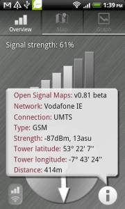
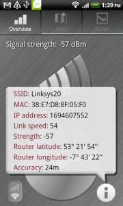
However it’s worth noting that their data is not complete and not updated in real-time. When I look at some remote areas or small cities, the number of cell towers found is way less than the large cities. It’s said they use Android app to collect cell sites and WiFi routers (yes, wireless routers), so it could be that Android cell phones are not so popular in those regions. If you have an Android mobile devices, their app will provide more information. For example, you can find which cell tower your handset is connected to and its data, it can also help you connect to a nearby WiFi hotspot and displays its SSID, MAC address and IP address and more. In the meantime, the app will log your nearby base stations and access points as well. They have not yet created an iPhone version, though.
The cell phone giant Apple, Google and Microsoft all have been recording cell towers and Apple and Google even got sued for tracking user whereabouts.